The Official
Journal of
The North
Carolina
Sociological
Association: A
Refereed Web-Based
Publication
ISSN 1542-6300
Editorial Board:
Editor:
George H. Conklin,
 North Carolina
 Central University

Board:
Bob Davis,
 North Carolina
 Agricultural and
 Technical State
 University

Richard Dixon,
 UNC-Wilmington

Ken Land,
 Duke University

Miles Simpson,
 North Carolina
 Central University

Ron Wimberley,
 N.C. State University

Robert Wortham,
 North Carolina
 Central University


Editorial Assistants

Rob Tolliver,
 North Carolina
 Central University

Shannon O'Connor,
 North Carolina
 Central University

John W.M. Russell,
 Technical
 Consultant
Submission
Guidelines
for Authors
Cumulative
Searchable
Index
of
Sociation Today
from the
Directory of
Open
Access
Journals (DOAJ)
Sociation Today
is abstracted in
Sociological
Abstracts
and a member
of the EBSCO
Publishing Group
The North
Carolina
Sociological
Association
would like
to
thank
North Carolina
Central University
for its
sponsorship
of
Sociation
Today
 ®
®
Volume 5, Number 1
Spring 2007
Facilitating Sociological Inquiry into Spatial Displacement with GIS
by
Christopher A. Badurek
Appalachian State University
Introduction
Mapping is a tool often used to express sociological relationships and portray the distribution and relative magnitude of social problems. Geographic information systems (GIS) are often used as a means of developing and creating these representations. However, GIS is often said to be more than just mapping by geographers and GIS analysts. The goal of this article is to explore and describe the general kinds of questions relevant to sociological inquiry that GIS helps analyze. GIS analysis can facilitate sociological problem-solving in both research and in learning experiences for undergraduates. Although in this case, GIS is described in the context of criminology and urban studies, the principles are transferable to other sociological problems where spatial extent is relevant.
GIS may be effectively used in research and teaching of sociology. In terms of teaching, it can enhance career skills for todays sociologist. These skills not only include foundational knowledge and facility with statistics and research methods, but may also include using GIS for doing research, creating reports, and engaging with community-based organizations. For example, university-community initiatives often include research and applied field experiences for students, such as in engaging in community policing research through direct analysis or through directly enhancing community dialog with law enforcement. These skills give students an advantage by increasing knowledge of how information technology tools can be effectively employed to address relevant sociological issues.
Ultimately, GIS is useful in research for not only visual representations of census and other data, but also for thinking, reasoning, and planning solutions to social problems. Primary themes evident in GIS analysis of social problems are in the spatial and temporal dimension. Therefore, the main point of this article is to discuss how GIS enables researchers and educators to examine the two fundamental aspects of sociological phenomena: spatial and temporal relationships. These two levels of inquiry dictate many kinds of questions that drive analysis in social science. For example, since social problems vary in space and over time, each has an impact on observed data. The following example of displacement addresses these issues in greater detail.
An Example of GIS Use: The Problem of Crime Displacement
The spatiotemporal analysis of crime has a long history beginning with preliminary approaches to the study of delinquency by criminologists in the nineteenth century. The burgeoning field of 'scientific criminology' was initially built on simple collection and inventory of demographic and geographic data. It was widely accepted that crime was associated with specific demographic characteristics, such as the spatial distribution of males as well as the young, poor, and uneducated. It was also assumed that clustering of criminal places could be predicted by urban form. Approaches based on mapping these factors can be traced back to the 1900s, particularly the use of pin mapping. The advent of GIS has allowed significant improvements over these prior static approaches. The relatively recent, rapid growth in the use of GIS by large police departments may yield even greater possibilities and variety of applications (Mamalian et al. 1998). Harries (1999) contends that evolution in analytic techniques remains rooted in the visual approaches of the major criminological schools of thought that have strongly influenced crime analysis approaches over the years.
In order to examine the benefits of using GIS in sociological research, consider the following displacement problem concerning crime. While the nations crime rate dropped steeply during the late 1990s, there is considerable debate over the exact causes of this decline (Bratton and Andrews 1999). Some policing experts have suggested the use of new policing tactics, such as the NYPDs CompStat system, have greatly contributed to this decrease. CompStat, a contraction of comparison statistics; utilizes crime data, GIS analysis, and organizational management practices to implement an aggressive anti-crime strategy. For example, this system generates weekly reports and maps based on crime statistics per precinct in order to compare with previous weeks as well as month and year to date totals. Time of day analyses are also used to visualize areas of crime increase. Weekly strategy meetings focus on identifying hot spots and areas of increase for immediate intervention. The following week, analysis of the weekly data would assess the success of the employed strategy.
According to Bratton and Andrews (1999), the deployment of this strategy coincided with a 68 percent decrease in murders and a 50 percent decrease in felonies over the years of 1993-1998 leading some NYPD leaders to claim they had reinvented policing strategy. However, skeptical criminologists argue that this drop in crime mirrors a nationwide decrease in crime rates related to decreases in levels of youth population and increases in employment. However, proponents of this method counter that the drop in New Yorks crime levels accounted for more than half the decrease in the national crime rate even as youth population rose slightly and unemployment remained consistently high there. Anecdotal evidence of their efforts to attack certain crimes with intervention tactics suggests their strategies had an effect on crime rates in specifically targeted areas.
This aggressive approach of identifying high crime areas to target, attacking the problem, and then examining the effects of the strategy inevitably leads to the complicated issue of what the overall effects are on crime across an area. The fundamental conceptual question is if crime has been eradicated from a location or merely pushed into a more desirable (or less, depending on ones perspective) location. For instance, such a strategy may have reduced the crime rate in a specific local area but the overall effects of the strategy are actually unknown without the context of the entire environment. Crime rates may have decreased in the area, but the question of whether it has been eliminated or merely displaced remains. In order to examine claims of efficacy of such policing strategies, the question of displacement or extermination of crime at a location needs to be resolved.
However, this is not an easy question to answer. The examination of crime displacement has been plagued by two major problems: how to identify kinds of displacement and how to measure and analyze such displacements. Barnes (1995) has identified six kinds of displacement of crime characterized by the following attributes: temporal, spatial, target, tactical, perpetrator, and the type of crime. Of these, policing strategies can affect only spatial, temporal, or target displacement as the others are based on offender identity and motivation. Previous research has mainly focused upon examining spatial displacement and has shown that making conclusions from analysis of local and global effects is quite difficult (Weisburd and Green 1995). Previous studies on temporal displacement are few, even though it has been stated that analysis of change is one of the "most crucial questions asked in police departments (Harries 1999, p. 12)." GIS use can help address the issues in this example by facilitating inquiry into three relevant dimensions of analysis: spatial relationships, temporal relationships, and the social context.
Kinds of Spatial Social Science Questions to Address
In socioeconomic research, boundaries are often perceived or socially constructed and analyses based on spatial relations focus on the criminal histories of places. In spatial analysis, boundary definitions and mismatch may significantly affect the results of socioeconomic studies. Addressing these issues is both an issue of applied and theoretical research. Geographic information science (GIScience) has been put forth as an emerging new discipline focused upon the theoretical foundations and social impacts of GIS. Leaders in this new field have advocated the formal study of the theoretical foundations and technological implications involved in GIS as a science concerned with applied and basic research, such as advancing conceptual knowledge of social science data and phenomena in order to improve GIS functionality and analytical methods.
GIScience is also concerned with the positive and negative impacts of GIS use in society. At the societal level, institutions, communities and the customs and laws of a society are examined as they relate to geographic information. The societal motivation examines how GIS use benefits or negatively affects society, such as through empowerment or disenfranchisement as a result of the application of GIS to community issues (Craig et al. 2002). For example, the use of the term 'participatory GIS' has been used to define research that describes the outcomes of GIS projects for a variety of community groups. It is well recognized that GIS can be used to simultaneously enhance the quality of life for one segment of society while also decreasing the quality of life for another. Examples from environmental justice studies demonstrate how GIS can be used for the optimal siting of toxic facilities in a region, which can often be at the expense of the health of low income communities. In response, GIS could also be used by organizations in such communities to bring this inequity to light and to push for remedial action.
Similarly, GIScience applies to social science as a whole in the sense of individuals, systems, and impacts of GIS on social issues and society as a whole (e.g., participatory GIS). For example, the research agenda termed Spatially Integrated Social Science (SISS) is centered on the importance of space in understanding and explaining human behavior in social science research and the use of location to integrate the efforts of the branches of the social sciences for addressing similar problems. Yet, so far, GIS has been most commonly used for crime analysis and geographic aspects of criminology.
Just as advances in information technology and computing will change the way science is performed, it will also ultimately enhance how social science analysis is performed. Although previous work (Garson and Biggs 1992, Vann and Garson 2001) has discussed the many possible uses of GIS in social science by presenting specific GIS functions and related examples of spatial analysis, it remains underused in social science research. It is most likely the case that GIS is underutilized because although most are aware of GIS, they do not use it due to the high learning curve and time required to acquire the skills to fully integrate it into research and teaching. For example, the NSF-funded Center for Spatially Integrated Social Science (CSISS) project aimed to address this limitation by establishing a center for training, research, and developing a cookbook of educational materials to support teaching (CSISS 2007). From a technological perspective, three barriers to wider GIS use have been identified as lack of interoperability, advanced knowledge of dimensionality and temporality in data, and ease of software use (Mark 2000). Overcoming these barriers requires a better understanding of how GIS is used by social science as well as the type of questions asked.
To make this happen requires greater engagement from social scientists with regards to application and particularly its relevance to theoretical understandings. For example, two major research needs identified in the UCGIS GI Science Applications White Paper on Crime Analysis (Getis et al. 2000) and by the NSF-funded CSISS project (Goodchild and Janelle 2004) were the development of computational tools for spatial analysis and dissemination of best practices using a variety of analytical techniques. Results from these efforts may develop new representations of hot spots for analysis and decision-making as well as analytical tools for GIS that facilitate the examination of spatiotemporal aspects of crime. For example, improvements to GIS may provide a framework for investigating displacement of crime over spatial and temporal dimensions through an investigation into the nature of change of crime rates.
Greater understanding of how GIS is used by criminologists and sociologists is also needed to expand the primary reasoning tasks currently supported by GIS. For example, GIS tasks generally use four primary visual operators: locate, identify, compare, and associate (Knapp 1995). These primary operators describe the general types of actions that can be taken when working with crime data. The locate operators are used to display where crimes have occurred within the larger social context or the social milieu. A prime example of this kind of work is to 'geocode' or place the locations of crimes from a spreadsheet onto a map space. The identify operator simply defines what kinds or categories of crime fall where. More importantly, they identify the distinguishing characteristics of the locations of crime problems as well as their spatial extent and possible origins.
Comparison operators are used to evaluate relationships between two sets of social factors as well as compare/contrast differences and similarities. The associate operators are used to more explicitly and crisply make conclusions about the relationships between two entities such as through exploratory or confirmatory statistical methods. While these methods clearly describe the geographic characteristics of social problems, they do not capture the full range of dynamics associated with real world phenomena. Therefore, examinations of the significant characteristics of time are needed to describe the kinds of temporal questions that may be addressed with GIS.
Change in Gun-Related E911 Calls from 2003-2004 in Buffalo, New York
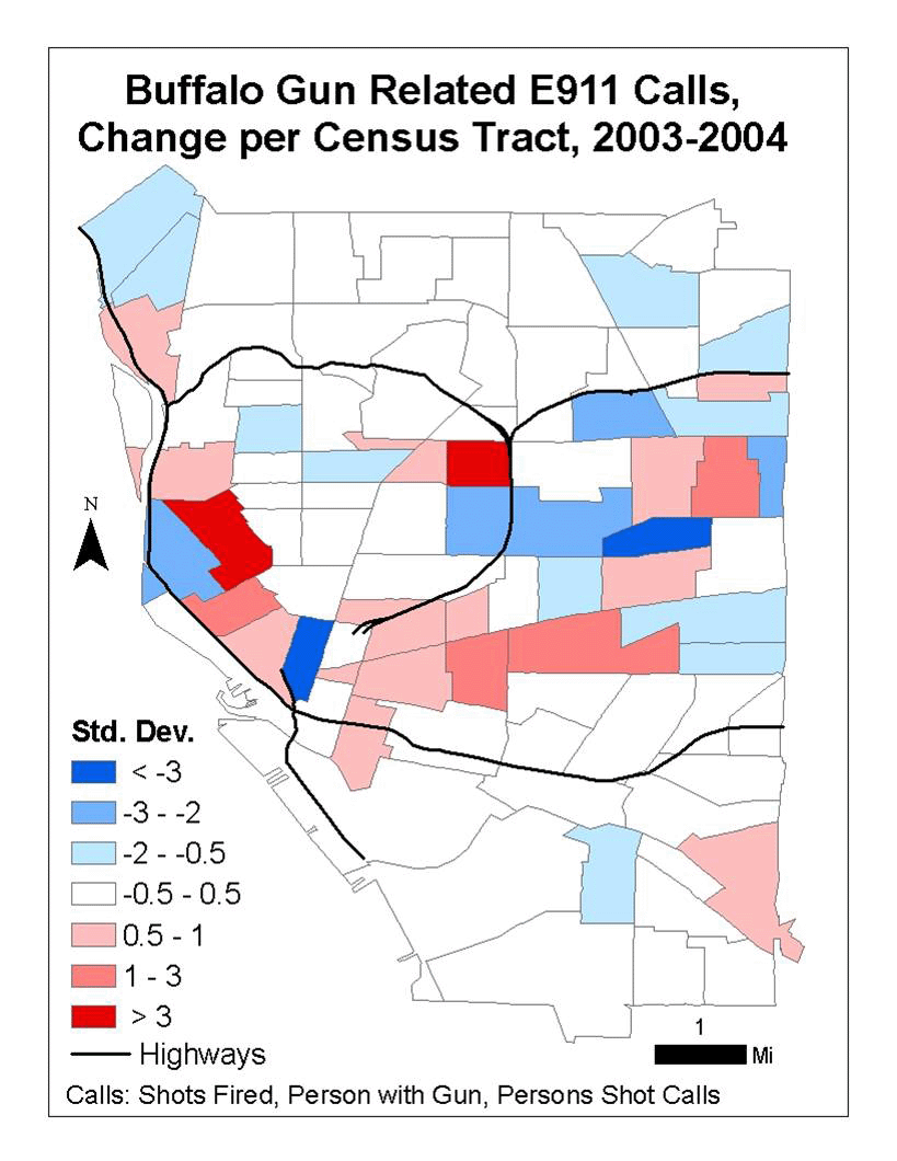
A practical application of GIS for the examination of possible displacements is found in the following example. In order to address what kinds of intervention strategies would be effective in reducing gun violence, analysis of gun related crime over several years was conducted in Buffalo, NY (Badurek et al. 2005). By examining aggregate statistics, gun crime was clearly declining in some areas and increasing in others. Using GIS to add a spatial component to the analysis yielded insight into the problem that could not be detected by statistical analysis alone. For example, Figure 1 shows the relative change in amount of gun-related crime in census tracts over a one year period. It is possible that the changes found in the analysis could have been related to effective law enforcement strategies targeting illegal firearms. However, it is also possible that the changes were related to significant changes in local drug markets in these specific locations. Anecdotal evidence suggests that the yearly change in gun violence was likely dependent on local level dynamics in drug markets in specific locations identified in the map. Competition among networks of distributors at the neighborhood and city-wide scale was likely occurring in two primary regions of the city. In this case, an emphasis on cracking down on these networks was proposed to be more effective than focusing on monitoring individual high-risk offenders.
This example demonstrates how GIS can be used to further examine the spatial and temporal relationships that underlie this first pattern. Perhaps one is taken by the relative surge of crime in the western part of the city and would explore at finer scales processes that may be better examined with a weekly temporal analysis. One may also note the adjacency of tracts with increasing crime to tracts of decreasing crime. Further exploration at finer spatial scales, such at the block level, may yield more insight into these trends. Is it the case that gun crime is moving from the east side of the city southward? Such questions can only be answered by further confirmatory analysis as well as further exploration at finer temporal and spatial resolutions.
Kinds of Temporal Questions to Address
In order to verify the various kinds of displacement that occur in reality, one must be able to ask questions about the behavior of individuals evident in spatial patterns in relation to overall trends. Some methods are inherently limited in their contribution to knowledge concerning the effectiveness of crime displacement due to their focus on static patterns rather than dynamics of associated behavioral trends. Therefore, queries concerning displacement are not just helpful but necessary to really understand the spatial relationships inherent to crime. Rather than relying solely on statistical studies of patterns found in hotspot analysis, we should determine the kinds of queries that should be expressed in this context to maximize the kinds of information that may lead to greater understanding of these complex phenomena.
Hotspot analysis is therefore most useful for targeting certain places as places to avoid (public) or to engage (law enforcement). It is also useful for targeting places for the death penalty, such as tearing down vacant properties or communities burning local crack houses. Clearly, making changes to places is easier than regulating individuals behaviors as promoted under 'broken windows' theory (Wilson and Kelling 1982). So, it may be that searching for hotspots that are to be addressed by police may be ineffective if there is displacement. The defining and characterizing hot spots may therefore be fruitless or at best inefficient without an approach that enables analysts to examine changes of crime over wide areas.
Generally, crime can be defined as an event composed of spatial and temporal attributes. Temporal aspects of these events can vary widely, yet temporal patterns are often significant in crime modeling and data analysis. To clarify this question, Sherman (1995) presents six dimensions of the criminal careers of places: (1) onset, or its birth as a high crime place; (2) recurrence, or the probability of a crime occurring in an area over time; (3) frequency, or the magnitude of how often crime occurs; (4) career length and desistance, or how long crime lasts per area and how it stopped; (5) intermittency, or explanations for breaks in the number of occurrences of criminality, such as due to vacancy of a property or weather effects; and (6) crime types, or explanations as to why some places are more conducive to criminal activity due to their spatial characteristics, such as street corner drug dealing or prostitution in parks.
Vasiliev's (1997) typology of time representations breaks these into five categories: moments, durations, structured or standardized time, and distance as a measure of time, and space as clock. In the context of crime analysis, conceptualizations corresponding to this taxonomy may include examination of crime along the following: the spatial and temporal distribution of crime events, frequency of events per spatial unit, durations of consistent crime rates, the extent of crime per police shift or per operation, and the probability that an offender committed crimes based upon the distance of their residence from a crime scene.
These conceptualizations can be further organized according to their temporal and spatial attributes. For example, Barnes (1995) presents a continuum of behaviors along four levels that define the primary elements of displacement that can be studied (see Table 1). First, the level of analysis can be at the individual and specific level, meaning examination of displacement is rooted in the decisions, motivations, and behavior of individuals. Secondly, the level of effects can be studied at the aggregate and general level, meaning we might be interested in how others learn from or follow the successes or problems of other criminals. Thirdly, the reach of impact of intervention can be studied to determine the degree that an offender is either displaced or stops acting at a particular location. Fourth, the temporal significance of displacement can be studied to determine how long displacement effects last.
Table 1
Typology of Crime Studies.
|
|
|
|
|
|
Profiling, Indentifying specific criminals |
Life-Cycles |
|
|
Pre-post intervention comparisons |
Durations,Cycles, Models, Spillover |
|
|
|
|
Discussion
One of the greatest strengths of GIS is to enhance thinking about social science research problems. Its effective use may even increase student interest and performance in social data analysis and research methods courses. Directly working with data and computing applications engages students and helps explain potential flaws in scientific reasoning. For example, consider the primary errors in thinking in social science research discussed by Babbie (2003). While the foundation of social inquiry is observation, inaccurate or limited social data are often a major stumbling block to accurate analysis. Using GIS for processing social data can expose the impacts of sloppy quantitative and qualitative data collection methods and limited sources of observation. Its use may also clarify the double-sided problem of overgeneralization and selective observation by demonstrating the effects of a small sample size and need for replication. This is where GIS may facilitate better understandings of the difference between exploratory and confirmatory kinds of analysis. By moving from data exploration to hypothesis confirmation students may be confronted with clarifying their biases and errors formed by rationalizing away alternate hypotheses. The use of exercises in social statistics or research methods courses that incorporate visual display of data and examine the effects of location on study results, such as those provided by CSISS (2007), would help to accomplish these goals.
Perhaps the most common error related to spatial analysis of sociological data is the problem of the ecological fallacy. This flaw in reasoning attributes characteristics of groups, measured by aggregate data, to individuals, measured by observations of individual behavior. To illustrate how GIS may improve social science reasoning lets reconsider the problem of displacement. The following table reflects the kinds of reasoning one may engage in with regard to displacement. Often, GIS analysis moves from the general to the specific, such as from individuals (addresses or blocks) to aggregates at the regional level (state-wide trends). In Table 1, the spatiotemporal aspects of analyses are classified according to these possible aggregate and individual scales of measure.
This table describes the effects of spatial and temporal units on kinds of analytical studies. For example, hotspots are usually short-term, address-based, and comprised of the sum of problems at individual locations. These are contrasted with spillovers, which examine long-term effects at the aggregate data level to examine overall trends in areas. Building upon Parkes and Thrift's (1980) model for studying urban change, Table 2 presents a typology describing sociological studies at various temporal and spatial scales. This figure presents a list of the most typical spatial and temporal units required for representative queries for studies concerning aggregates (a) and individuals (i) to support reasoning about events and social processes.
Table 2
Typology of Spatiotemporal Scales for Social Science Studies
|
dress |
|
bor- hood |
|
|
|
|
|
|
|
|
|
|
|
|
|
|
|
|
|
|
|
|
|
|
|
|
|
|
|
|
|
|
|
|
|
|
|
|
|
|
|
|
|
|||||
|
|
|
|
|
|
|
|
|
|
|
|
|
|
|
|
|
|
|
|
|
|
|
|
|
|
|
|
|
|
|
|
|
|
|
|
|
|
|
|
|
|
|
|
|
|
|
|
|
|
|
|
|
|
|
|
|
|
|
|
|
eration |
|
|
|
|
|
|
|
|
Adapted from Space and Time Scales
(after Parkes and Thrift 1980, p. 129).
A primary benefit of GIS use in social science education is to help students make a better link between judgments and scientific reasoning. GIS facilitates reasoning about social problems by allowing analysis of displacement at both the individual and aggregate levels and at different temporal scales. Consideration of the possible underlying processes in the following example explains the differences between these kinds of micro and macro-scale levels of reasoning.
To demonstrate the value of clarifying appropriate temporal scales, consider property value histories that follow Downs (1981) Stages of Neighborhood Change (see Table 3). This example describes the change of a vibrant, viable neighborhood to one of complete deterioration. Neighborhoods in Stage 1 refer to thriving or consistently well-off urban areas characterized by rising property values and good quality housing stock. Those in Stage 2 are characterized by generally stable property values, slightly declining housing stock, and higher population densities than Stage 1. Stage 3 is characterized by housing stock in clear physical decline, high density rental populations, and evidence of absentee landlords and abandoned properties. Stage 4 neighborhoods are characterized by very poor housing quality, very low property values, and prevalence of population living at subsistence level. Stage 5 describes the worst case, with high number of abandoned and decayed properties and population at the very lowest end of economic strata.
Table 3
Stages of Neighborhood Decline
|
|
|
|
|
|
|
Viable |
Decline |
Decline |
Deteriorated |
and nonviable |
In the application of GIS to address social problems, the tasks of prediction, comparison, and description lead researchers to choose certain variables. Within the sociological perspective, some scales of study are clearly more appropriate than others. The cases of individuals at microscale levels of analysis have been commonly studied, including life histories and events on street corners. Yet, the appropriate scales of study are a reflection of the social processes at work. For example, models of urban development such as Hoyts (1939) classic model are often focused on relevant push-pull factors at a city-wide or even regional suburban scale. However, these models may require integration of regional level analyses with studies of local processes that may only become apparent through data collected from neighborhood block clubs or other social organizations. Therefore, proper analysis of sociological spatiotemporal processes depends on thorough data collection at the proper spatial and temporal scales.
Figure 2
Change in Property Value Histories Over Quarter Time Units
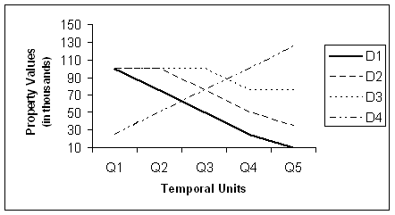
To address the higher order question of how and why neighborhoods decline, data at certain spatial and temporal scales are required. According to the typology of spatiotemporal scales for social science studies described in Table 2, this problem could be best addressed at the neighborhood level and within the temporal scales ranging from hours to life-times. To clarify, consider a scenario dealing with change in average property values in areal units within an urban-suburban region over five quarter time units (see Figure 2). In this particular case, we are interested in examining the change of an inner urban district (D1) in relation to two neighboring urban districts (D2, D3) and another close district located with a suburban region (D4). Determining if similar social processes are occurring with regard to neighborhood decline can only be based on evidence gathered from similar temporal sequences. Therefore, questions related to the displacement of neighborhood decline to adjacent areas can be effectively explored through GIS analysis at appropriate spatiotemporal scales.
In this scenario, changes that occur to these districts over five temporal time units is shown with respect to average property values among the following urban areas: one that is adjacent and one that is disjoint and separated by a relatively large distance. In this example, it is clear that the urban district adjacent (D2) to the inner urban district is undergoing a similar rate of decay while the suburban district (D4) is experiencing the opposite kind of change altogether (see Figure 2). In this case, one may be interested in the interrelationships between units D2, D3, D4 and ask how is one related to the next? Studies integrating such spatiotemporal data provide possible explanations of displacements, particularly if they are random or autocorrelated. These explanations are a prime example of the importance of the spatial perspective in social science.
Recently, there has been a resurgent interest in the spatial perspective in social science. GIS is increasingly being recognized as an analytical tool within the multimethod toolbox of social scientists. Although sociologists are becoming more familiar with GIS, the limitations of costs and steep learning curves remain high. Another possible limitation stems from the perception that effective use of GIS is limited to quantitative data analysis. This is not necessarily the case as it may be employed as an effective qualitative method to meet the following research goals: description, exploration, and explanation. For example, in the context of urban analyses, immediate qualitative feedback can be elicited from public meetings concerning different views on the same social issue. Further possible sources of data are neighborhood surveys, census data, focus groups, and community needs assessments (Steinberg and Steinberg 2006). One may even predict effects of revitalization and project future displacements. Effective use of GIS to address significant social problems of this kind may even elevate the status of social science studies in the public eye.
Conclusion
GIS is a tool with great potential for enhancing sociological research in sociology and in teaching sociology. However, effective use of GIS in research and teaching is much more than just mapping the locations of events. It also requires a specific way of thinking about and addressing sociological problems. The term GIScience captures this idea as it describes research with its tripartite focus on better application, enhancing technology through research, and examination of the social implications of GIS use. Sociology students can clearly benefit from effective use of GIS and apply associated skills to careers in law enforcement, community action, government employment, and social work. Effective use of GIS can not only significantly enhance the research of sociologists where spatial extent is relevant but may also enhance the learning experiences and career opportunities of sociology students.
References
Babbie, E.R. 2003. The Practice of Social Research. Belmont, CA: Wadsworth.
Badurek, C.A, Beal, P., and St. Jean, P.K.B. 2005. "Comparing Areas of Risk of Recidivism for Parolees and Probationers Identified as being Potential Contributors to Gun Violence." Proceedings of the 8th Annual International Crime Mapping Research Conference, Savannah, GA, September 7-10, 2005.
Barnes, G.C. 1995. "Defining and Optimizing Displacement." In: Eck, J.E., and Weisburd, D., (Eds.), Crime and Place. Monsey, NY: Criminal Justice Press. pp. 95-113.
Bratton, W.J., and Andrews, W. 1999. "What We've Learned about Policing." City Journal 11, Spring 1999.
Craig, W.J, Harris, T.M., and Weiner, D. 2002. Community Participation and Geographic Information Systems. Boca Raton: CRC Press.
CSISS. 2007. Center for Socially Integrated Social Science: Spatial Resources for the Social Sciences. <http://www.csiss.org.> Last accessed May 1, 2007.
Downs, A. 1981. Neighborhoods and Urban Development. Washington, DC: Brookings Institution.
Garson, G.D., and Biggs, R.S. 1992. Analytic Mapping and Geographic Databases. Sage University Paper series on Quantitative Applications in the Social Sciences, 07-087. Newbury Park, CA: Sage.
Getis, A., et al. 2000. "Geographic Information Science and Crime Analysis." Journal of the Urban and Regional Information Systems Association 12: 7-14.
Goodchild, M.F., et al. 1999. "Introduction to the Varenius Project." International Journal of Geographical Information Science 13: 731-745.
Goodchild, M.F., and Janelle, D.G., (Eds.) 2004. Spatially Integrated Social Science. New York: Oxford University Press.
Harries, K. 1999. Mapping Crime: Principle and Practice. Washington, DC: US Department of Justice, Office of Justice Program, National Institute of Justice, Crime Mapping Research Center.
Hoyt, H. 1939. The Structure and Growth of Residential Neighborhoods in American Cities. Washington, DC: Federal Housing Administration.
Knapp, L. 1995. "A Task Analysis Approach to the Visualization
of Geographic Data." In: Nyerges T.L., et al. (Eds.), Cognitive
Aspects of Human-Computer Interaction for Geographic Information Systems.
Dordrecht, Boston: Kluwer Academic Publishers, pp. 355-371.
Mamalian, C.A., et al. 1998. The Use of Computerized Crime Mapping by Law Enforcement: Survey Results. Washington, DC: U.S. Department of Justice, Office of Justice Programs, National Institute of Justice.
Mark, D.M. 2000. "Geographic Information Science: Critical Issues in an Emerging Cross-Disciplinary Research Domain." Journal of the Urban and Regional Information Systems Association 12: 45-54.
Parkes, D., and Thrift, N. 1980. Times, Spaces, and Places: A Chronogeographic Perspective. New York: Wiley & Sons.
Sherman, L.W. 1995 "Hot Spots of Crime and Criminal Careers of Places." In: Eck, J.E., and Weisburd, D., (Eds.), Crime and Place. Monsey, NY: Criminal Justice Press. pp. 35-52.
Sherman, L.W., Gartin, P.R., and Buerger, M.E. 1989. "Hotspots of Predatory Crime: Routine Activities and the Criminology of Place." Criminology 27: 27-55.
Steinberg, S.J., and Steinberg, S.L. 2006. Geographic Information Systems for the Social Sciences. Thousand Oaks, CA: Sage.
Vasiliev, I.R. 1997. "Mapping Time, Monograph 49." Cartographica 34 (2).
Vann, I.B., and Garson, G.D. 2001. "Crime Mapping and Its Extension to Social Science Analysis." Social Science Computer Review 19: 471-479.
Wilson, J.Q., and Kelling, G.L. 1982. "The Police and Neighborhood Safety." The Atlantic (March), pp. 29-38.
Weisburd, D., and Green, L. 1995. "Measuring Immediate Spatial Displacement: Methodological Issues and Problems." In: Eck, J.E., and Weisburd, D., (Eds.), Crime and Place. Monsey, NY: Criminal Justice Press. pp. 349-361.
Return
to Sociation Today, Spring 2007
©2007 by the North Carolina Sociological Association