The Official
Journal of
The North
Carolina
Sociological
Association: A
Refereed Web-Based
Publication
ISSN 1542-6300
Editorial Board:
Editor:
George H. Conklin,
 North Carolina
 Central University

Board:
Bob Davis,
 North Carolina
 Agricultural and
 Technical State
 University

Richard Dixon,
 UNC-Wilmington

Ken Land,
 Duke University

Miles Simpson,
 North Carolina
 Central University

Ron Wimberley,
 N.C. State University

Robert Wortham,
 North Carolina
 Central University


Editorial Assistants

Rob Tolliver,
 North Carolina
 Central University

Shannon O'Connor,
 North Carolina
 Central University
Submission
Guidelines
for
Authors
Cumulative
Searchable
Index
of
Sociation
Today
from
the
Directory
of
Open
Access
Journals
(DOAJ)
Sociation Today
is abstracted in
Sociological Abstracts
and a member
of the EBSCO
Publishing Group
The North
Carolina
Sociological
Association
would like
to thank
North Carolina
Central University
for its
sponsorship of
Sociation
Today
 ®
®
Volume 4, Number 2
Fall 2006
Land Use Planning and The Consequences
of
"Smart Growth"*
by
Bob Jentsch
I'll take a few minutes to hopefully make us think about what really goes on in the world of land use planning and the consequences of Smart Growth, a recent buzzword that implies that all growth is good, if it is planned. I'll do this by making some sweeping generalizations about city planning not working and justifying my opinions by giving some examples. I'll tell you who is to blame for the land use planning process not working, and lastly I'll offer a partial solution.
My comments will be limited to city/urban planning, which is played out in the physical development of a city (not regional, national or policy planning). Urban planning is a systematic creative approach to address and resolve social, economic and physical problems of cities. In an undated pamphlet published by the American Planning Association entitled, "Had You Planned to be a Planner?", it is stated that "Planners formulate plans and policies to meet social, economic, and physical needs, and they develop the strategies to make these plans work. Planning is both a science and an art."
City planning has been practiced the same since the 1920's in the U.S. and will continue to be done the same way for the next 80 years. The problems with city planning are the same throughout the U.S., so when I use Durham, North Carolina, as an example, it should not be taken personally. In my opinion local government operates pretty well. My comments are limited to the planning process.
Consider the map below which is typical of the planning process. Plans, of which maps are a part, are really visions of the future to meet the social, physical and economic needs of everybody. Plans consist of a map and a text which explains the map. That is a comprehensive plan. Planning is also called a process. The process you use to get there is called a zoning ordinance. In Durham we call that the UDO or Uniform Development Ordinance. The ordinance, including many hundreds of tables, tells you exactly how you can develop your land today. It is very clear and I am being facetious. It is a highly political process, and the process does not work in the way it is intended to work.
Durham's Future Land Use Map
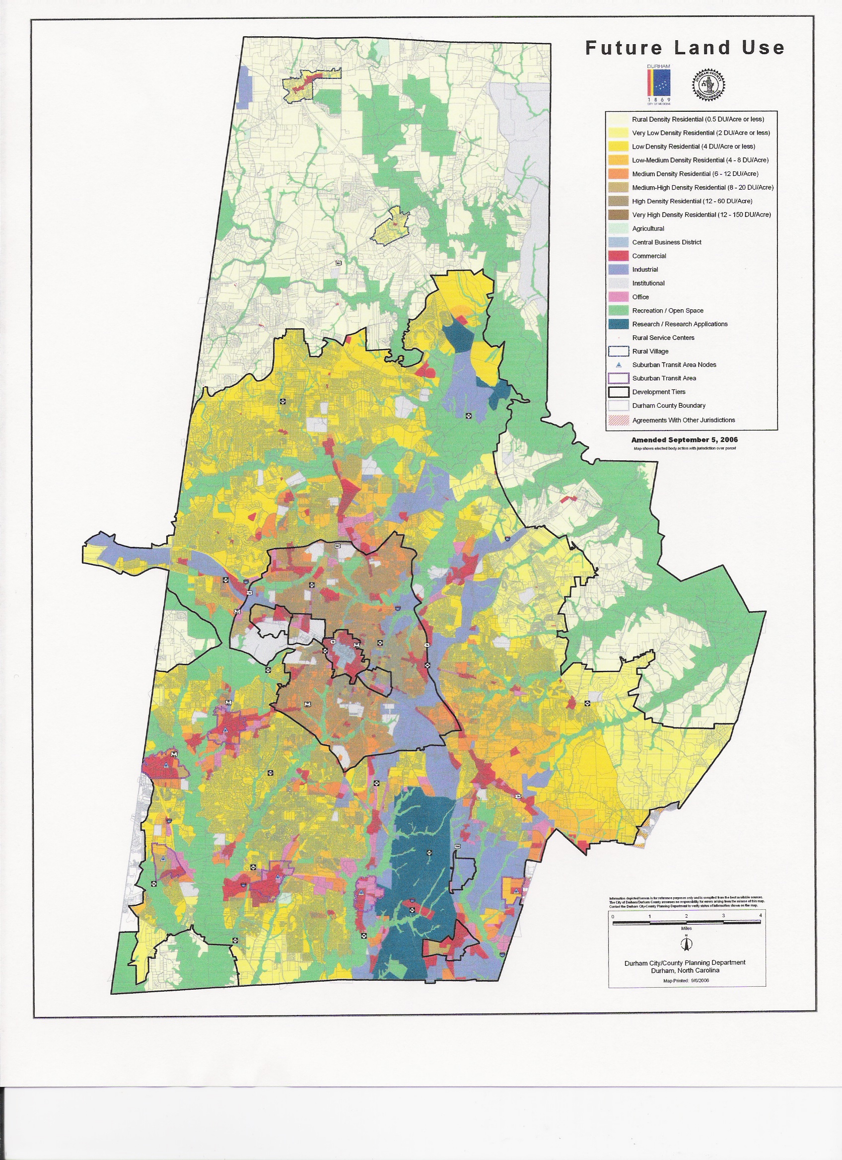
Durham's newly adopted comprehensive plan is underutilized, often misinterpreted, and is overly complicated, which renders it more than useless, because we delude ourselves into thinking that because we have this plan, we are building a better community for the general welfare of the citizens, when in fact we most often ignore the plan and how it affects people. That is the social aspect that gets ignored most often, which is the first thing mentioned in those definitions of planning and of what planners do.
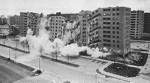
I worked as a junior planner in my first planning job in St. Louis in the mid 50's. St. Louis had a comprehensive plan that had been prepared by perhaps the best known and respected planning firm in the country at that time, Harland Bartholomew and Associates. Pruitt-Igoe, a high-rise public housing project, had been recently built and designed by one of the countrys most eminent architects, Minoru Minoru Yamasaki, who would later design the World Trade Center. This was my first planning job and I was generally unaware of what was going on, but I did have some very distinct impressions. In addition to seeing the massive high-rise buildings (between 6 and 10 buildings) called Pruitt-Igoe, I saw block after block of cleared land, and I was really shocked because it looked like a bombed-out area. The area had been housing occupied by low-income, predominantly Black citizens, and no one had kept track of where they had relocated to or what had happened to the thousands of displaced persons. I think it was assumed, but nobody knew, that they would come back and live in Pruitt-Igoe. (See a video segment of the Jentsch presention in .mp4 format). Link here
I left St. Louis to go back to school, and within 10 years I learned of the complete demolition of Pruitt-Igoe, and as you see in the picture they used dynamite to collapse the buildings. By any standards this well-thought out, well-planned project was an economic and social disaster.
A second issue about plans, including the one in Durham, can be seen in the map itself. Look at the map. It is very pretty. It shows where the roads go, or where they ought to go. It shows where the houses go or ought to go, apartments should go, as well as shopping centers (often in red), parks and schools, flood plains, and open space.
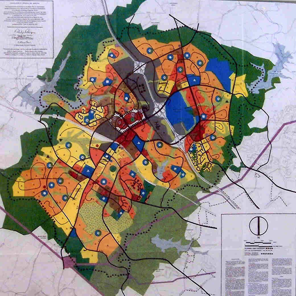
But what is both usual and unusual about planning maps in general it is as if the cities are an island all by themselves. The maps tell you nothing about what is going on in the region or at the edge of the city. Most city plans are just like the maps from Durham or Germantown (below), considering a city as an island isolated from the region. Most plans that I have worked on in 40 years, including some that I have developed, all have this fault. Now that is not very smart. This is one of the things that make plans unworkable.
Here is a planning map of Germantown, Maryland. It also shows the city with the planning faults I just described. Notice the green areas around the edges of town, which I elaborate on below.
Why do you have the right to control land this way? It is because the Constitution says you have the right to do things for "the public good." When I first started in planning, I drew plans like the maps show, which affected a lot of people. If you are making a decision about where a road goes, it is going to affect a lot of people. If you are making a decision about where a school goes, it also is going to affect a lot of people. Public health, safety, morals, police power and general welfare are general terms. But what do they mean?
If you are making a map and deciding what a person can do with his property, how can you decide what is best for the general welfare? You have to express this in the map which shows the physical development of the community.
One thing to consider is economics. But in Durham, for example, the Comprehensive Plan under its Economic Development sections mentions the Research Triangle Park only in passing, because it is outside the circle which is centered on downtown, ignoring the region in which the city lies, even though most of RTP is within the county of Durham. (You may view the plans here, if you wish.) Agriculture preservation is mentioned, but not RTP. Targeted development downtown is covered, as are compact neighborhoods and infill. Is this planning for the future of the city and county?
Planning should also translate the social dimension into the physical layout of the land, but all is done in a political environment.
Can I consider all this when deciding what to do with an individual piece of property? Absolutely not. Do we do it? Absolutely yes. There is no way that any human can think of all these factors and crank it into the plan and do it correctly. But we do it. My contention is that you cannot develop an idealistic city because you are not in control, plus you cannot even think about it correctly.
The planning process is highly discriminatory. By that I do not mean racially discriminatory. Without adequate information, plans designate private property for specific and limited uses. If you own a piece of land planned as commercial, you get a large financial bonus from the decision. But if you own land designated as a park (green), your land is worth very little. That gives one person more than another arbitrarily, and that is one definition is discrimination.
I've done many plans. Did I think about the social aspects of these plans? I'd like to think I did, but in reality I have to concentrate on the physical aspects of the city because I can handle that. This is the usual process in city planning.
Who is to blame for city planning not working? The easy answer is to blame the elected officials. After all they are the ones making final decisions, so let's throw the bums out. In my opinion, they could make better land use decisions if they wanted to, but the problem is deeper. Our government system is structured with a built-in conflict between long-range land use planning and the people who make the decisions, the elected officials. The comprehensive plans are usually designed with a 20-30 year horizon, in order that they will consider future citizens. The people who make the decisions (elected officials) and implement this plan, are thinking about their next election campaign two or three years down the road perhaps. So if plans are made with future citizens in mind, and elections are decided by existing and registered voters, and taxes are paid by existing property owners, to me it is obvious who and what gets the attention.
Partial Solution: What Do We Do?
I think it is useful to get involved and informed and participate in politics and land-use planning decisions, particularly those that affect you personally, and in the area that you live, and the surrounding areas.
*Footnotes
Bob Jentsch is a retired urban planner and former faculty member at George Mason University. He was a long-term member of the Durham, North Carolina Planning Commission, and a member of the group when the Uniform Development Ordinance and the Durham 2030 Plan was adopted. A modified version of this paper was presented at the 2006 Annnual Meeting of the North Carolina Sociological Association.
Further Reading
In order to understand
some problems of the Pruitt-Igoe project and how to design safer cities,
it is necessary to look at the work of Oscar Newman and his book Creating
Defensible Space (HUD: 1996). This book is still ignored
by planners who basically reverse its findings. To download the book
free from HUD, use
this link.
http://www.huduser.org/
publications/pubasst/defensib.html
©2006 by the North Carolina Sociological Association